Palisade
Town Float
Difficulty:
Class I/II
Craft:
Raft
Ducky
Kayak
SUP Board
Canoe
Elevation:
Put in – 4,728ft
Takeout – 4,644ft
Length:
10 miles
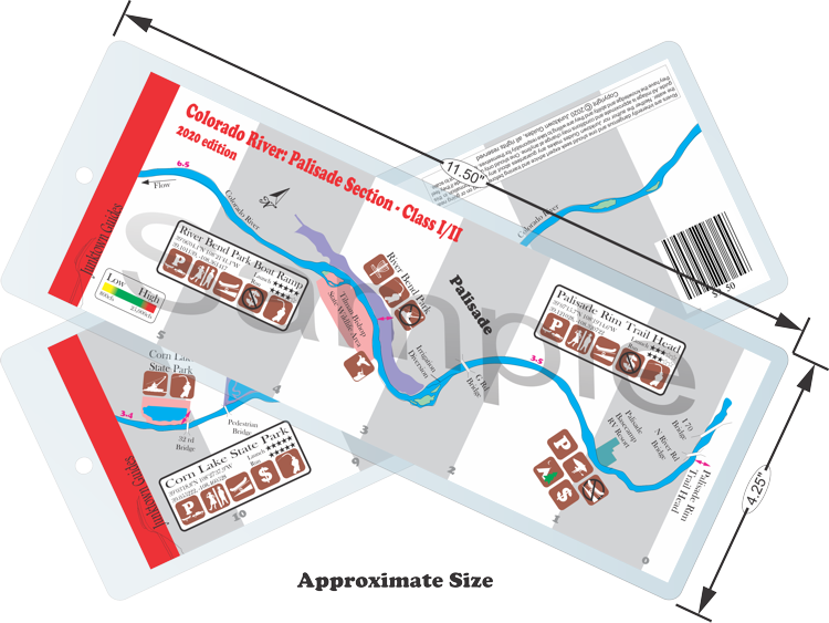
This regular size map covers approximately 11 river miles on the Colorado River in the Grand Valley.
This is a beautiful run at the beginning of the Grand Valley with views of the Grand Mesa, Book Cliffs, and Mount Garfield. This relatively mellow stretch makes for a good float and it is a good place for introducing new people to the river at low flows. There are no rapids to speak of on this stretch however there are a few wave trains that add a little excitement every now and then. Some of the side channels can add a little more excitement at higher flows but you can get stuck and have to walk at lower flows.
Most people run from River Bend Park to Corn Lake but the stretch between the Palisade Rim Trailhead and River Bend is quite beautiful and worth running. Back when I lived in Palisade near River Bend Park (when I first moved to the Grand Valley) I would often run from Palisade Rim to The Bend and it only took a couple of hours leaving the rest of the day open to do other things.
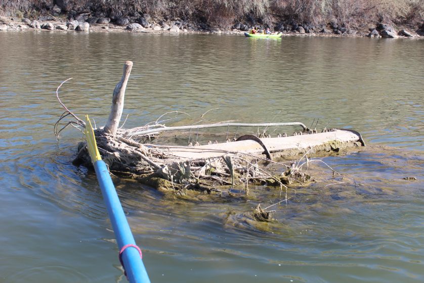
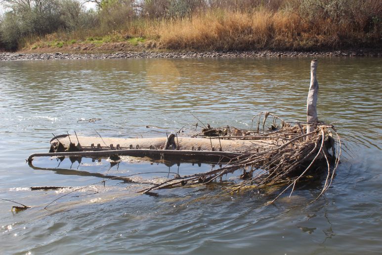
There is a big piece of metal farm equipment, with nice shape things that would love to open up your raft, in the middle of the river about half way between River Bend and Corn Lake (39.075720, -108.418334). The pictures to the right were taken early season 2020 when the flow was around 600 and that was the first time I’ve seen it out of the water. Usually it lurks just below the surface. This is about 100 yards after the big grated inlet for the Clifton Water District water treatment plant on river right. Hopefully in time we can get someone to remove this hazard but until then please be careful.
The Tilman Bishop State Wildlife Area is a 100+ acre Colorado State Park where one can hunt deer, water fowl, and small game as well as fish. This Park is named after Tilman “Tillie” Bishop, “Colorado’s fourth-longest-serving legislator, served as a state representative and state senator. He also was a Mesa County Commissioner, University of Colorado Regent and Colorado Mesa University Trustee”, according to an article in the GJ Daily Sentinel. Reservations are required to hunt here and they can be obtained through the state’s website.
Flow:
The gauge in the Beta box above is only accurate after the Gunnison River converges with the Colorado. American Whitewater has a read above the roller dam in the De Beque Canyon, which excludes everything they take out for the Highline Canal and what comes in at Plateau Creek, and then doesn’t pick up again till State Line. To get a more accurate read on the flow between Plateau Creek and the Gunnison Confluence take the state line reading and subtract the Gunnison reading and this will get you close enough though this doesn’t account for the iragation canals that dump back into the river. Don’t over think it though, a good flow at state line most likely means a good flow on this stretch, high water will mean high water everywhere.
For more information on the Colorado River through the Grand Valley head over to our Grand Valley page.

Water sports are inherently dangerous sports in which severe injuries or death may occur.
Do not use this website or maps unless you are an expert, have sought out and obtained qualified professional instruction or guidance, are knowledgeable about the risks involved, and are willing to assume personal responsibility for the risks associated with these activities. If you have any doubts in your ability please stay off the water.
DO NOT USE THIS WEBSITE OR MAPS UNLESS YOU ARE WILLING TO ASSUME PERSONAL RESPONSIBILITY FOR THE RISKS ASSOCIATED WITH THE ACTIVITIES DESCRIBED OR DEPICTED!!!