Glenwood
Springs
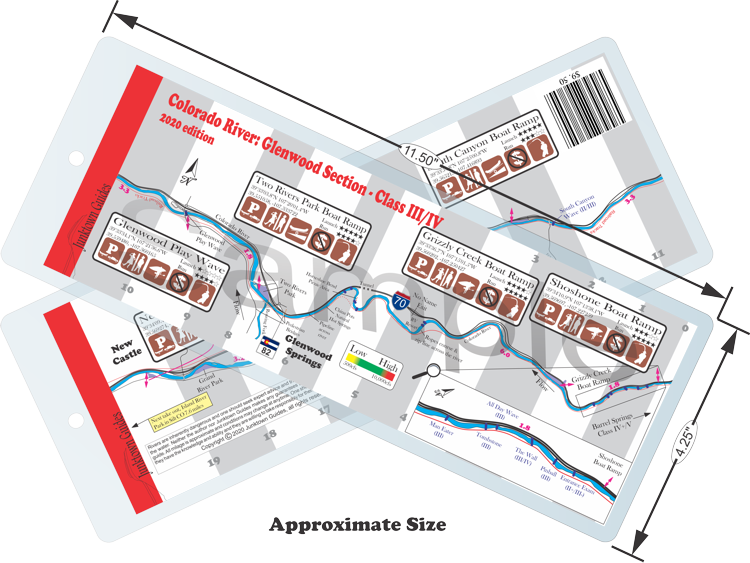
Difficulty:
Class III/IV
Craft:
Raft
Ducky
Kayak
SUP Board
Canoe
Elevation:
Put in – 5,954ft
Takeout – 5,552ft
Length:
19.5 miles
Above Roaring Fork
Below Roaring Fork
This regular size map covers approximately 19 river miles on the Colorado River through Glenwood Springs CO.
Glenwood Springs Colorado is a truly special place. This is a small mountain town that exploded in population thanks to its location on the I70 corridor and its proximity to Aspen. Despite all the hustle and bustle one can still seek adventure right in the middle of town and have hwy access to it all. If you are looking for a remote mountain experience this isn’t it, but, you can have world class rapids and amazing views with an easy shuttle, picnic areas, toilets that flush, and the safety of knowing you can always get off the river and walk the bike path or flag a car down to get help. Don’t get me wrong, I love the more remote, peaceful runs where one can forget the rest of the world exists. Sometimes it’s nice to leave my house in Grand Junction at 9am, meet up with friends at the takeout by 11, be on the water by noon, at the brewery by 5 and back home in bed by 11pm. And if you live in Glenwood you can do it all right after work.
Glenwood Canyon is a place of true beauty with sandstone and limestone cliffs cut deep by the water of the Colorado River. When I70 was completed through this canyon in 1992 it was considered one of the greatest engineering feats of the 20th century. A dam and the Shoshone powerplant prevent one from running the entire canyon however much of the canyon is still runnable with the difficulty increasing as you put in closer to the dam.
Barrel Springs:
Barrel Springs is the first river section after the dam, it goes from the Hanging Lake exit to the Shoshone exit. It often is seen without any water in it as water is diverted from the dam and run through the Shoshone powerplant providing power to the city of Glenwood Springs and surrounding area. Completed in 1909, the powerplant depends on the flow of the river not the water stored in the reservoir to produce power so it is a river run plant. The only time you’ll see water in the river is during the spring runoff when more water than is needed to provide electricity flows through the canyon.
When it flows, this stretch of river is class IV/V with rapid names like Upper Death and Lower Death. The difficulty of the river is only one aspect that makes this an expert run. Hanging Lake is a hugely popular hike that requires a permit to get on the trail. This run takes a logistical ninja just to get to the put in so I left it off the map as I figure by the time someone has the skill do this run both river wise and logistics wise, they don’t really need a map like this.
Shoshone Power Plant:
While short, this run sure is sweet, one of the best intermediate miles of whitewater in the state. I 70 allows for easy shuttle from Grizzly Creek back up to the Shoshone exit but there is also a bike path along the entire stretch that would allow one to get off after the last rapid and carry their gear back up to the top to run it again. This stretch is technical and continues leading me to not recommend this run for anyone that is not a solid intermediate boater and at high water only advanced boaters should be looking at it. When I’m teaching kayaking, we often have the beginners wait for the more advanced boaters at the Grizzly Creek put in as we run from Shoshone to them, then we all continue down river together. This makes for a much nicer day and everyone gets a little something.
The power company releases the water back into the river at the plant making the run from here flow year-round. For as far back as anyone can remember there has been a tradition amongst kayakers of running Shoshone on New Years Day every year with people coming from all over just to say they’ve done it.
Grizzly Creek:
Grizzly Creek is a small creek that drains into the Colorado River and for the most part is not runnable, that said people have run it in kayaks. Most people consider the run from the Grizzly Creek Rest Stop to Two Rivers Park to be “The Grizzly Creek Run” or refer to it as “running Grizzly”. For the beginner to advanced beginner this is one of the best runs in the state. At higher flows some of the rapids can approach class III but most of the years they are a solid II/II+. At higher water the wave trains can get big and intimidating for beginners but wave trains are generally friendly making it seem scarier than it really is. There are a couple of holes around the Horseshoe Bend area that will toss a beginner but the recovery is usually good. For the first 5 miles of this run you are floating through the canyon with plenty of flat-water sections that allow you to look around and really soak in the view. The picnic area at Horseshoe Bend is a great place to stop for lunch and the China Pots Natural Hot Springs is a welcome treat at low water towards the end of the canyon.
Two Rivers Park and Below:
From Two Rivers Park down it is mostly flat-water with a couple of places that will be challenging for beginners to advanced beginners. The Glenwood Play Wave is a river wide, man-made feature that has different elements to give more play at different flows. If running the wave there is a boat ramp on river right that is the easiest way through. Running straight through anywhere but on the ramp could be not only more challenging but more dangerous as you could collide with someone surfing the wave, best to stay right for your safety and others.
The next challenge after the wave is the South Canyon Wave. At certain flows this provides a nice play wave but for the beginner it can be challenging. If one swims at the wave, they would have to work hard to avoid a bridge abutment at higher flows. At lower flows the abutment is out of the water. Dinosaur Rock is next, at low flows this rock is completely out of the water but at high water this rock creates a hole big enough to swallow an 18ft raft. It is relatively easy to avoid by going either right or left of it. This rock gets its name from the imprint of dinosaur bones in it. From here it’s a relatively easy float with a nice gradient drop just before the New Castle Boat Ramp that creates a fun wave train.
River Access Points
The most popular run is either Shoshone or Grizzly down to Two Rivers. This is by far the most scenic however the stretch from Two Rivers down has its own beauty.
I usually run different distances depending on flow:
High water- Grizzly to New Castle
Medium High- Grizzly to Tibbets
Medium Low- Shosho to South Canyon
Low- Shosho to Two Rivers

Water sports are inherently dangerous sports in which severe injuries or death may occur.
Do not use this website or maps unless you are an expert, have sought out and obtained qualified professional instruction or guidance, are knowledgeable about the risks involved, and are willing to assume personal responsibility for the risks associated with these activities. If you have any doubts in your ability please stay off the water.
DO NOT USE THIS WEBSITE OR MAPS UNLESS YOU ARE WILLING TO ASSUME PERSONAL RESPONSIBILITY FOR THE RISKS ASSOCIATED WITH THE ACTIVITIES DESCRIBED OR DEPICTED!!!