North Fork
Other Runs
Smith Fork of the Gunnison
Class: V with mandatory portage
Who: Those seeking type II fun that boarders on type III
Length: 10.2 miles, mostly flat water
Season: Spring Runoff
Gauge: visual
The Smith Fork is not run very often in a boat but in talking with some friends from Cedaredge they tell me the way to run it is with a drybag, PFD and wetsuit, canyoneering style, at low flow. For those that decide to run it in a kayak however, this is a very narrow creek that doesn’t have a lot of room to maneuver. The first mile or so is all flat water and looks more like an irrigation ditch, and the last half mile before the confluence has a mandatory portage. The first couple of miles floats through private property so be respectful.
This has been described as a suffer fest with about a mile or so of pretty good Class V rapids before it goes into a sieve and mandatory portage just before it dumps into the Gunnison River at the tail end of the Gunny Gorge. Definitely not a destination run but if you live in the area and subscribe to the 100 bad days make a 100 good stories philosophy, this could be a good run to keep an eye on.
Put in where the Fruitland Mesa Road bridge crosses the creek off of 3400 RD, avoid the bridge off of 3300 RD as that is all private property. Take out at the Gunnison Forks River Access, same takeout as the Gunny Gorge.
Muddy Creek
Class: IV/V
Who: If you’re in the area and looking for a short hard run
Length: 2 miles
Season: Spring Runoff
Gauge: visual
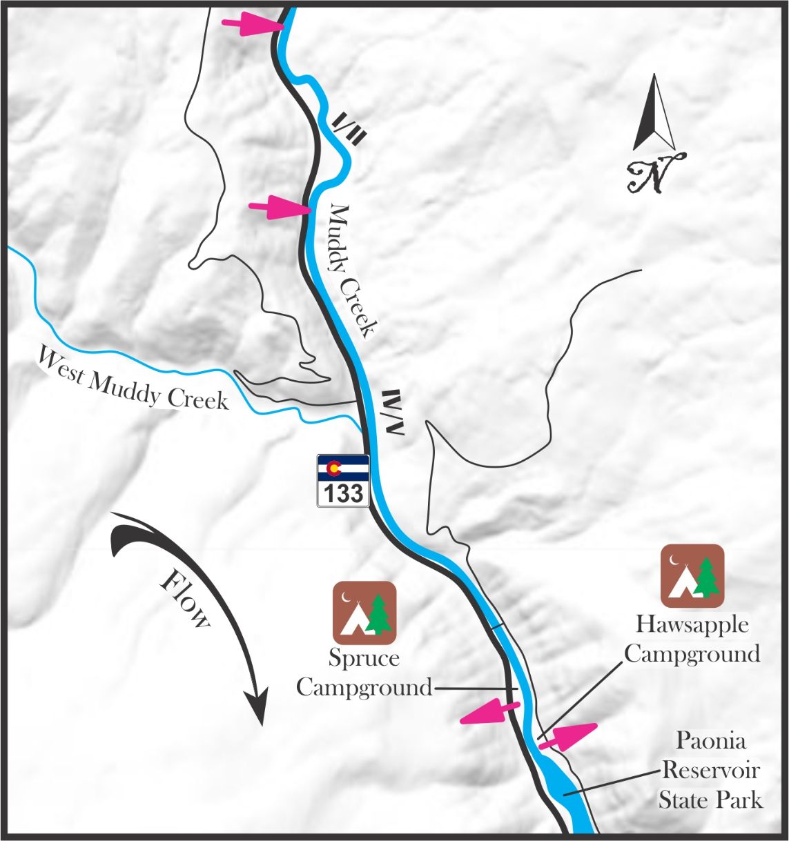
The name Muddy Creek seems to have been more of a catch all name that just kind of stuck. This isn’t the only Muddy Creek in the area, there is another one that flows into Crawford Reservoir and it was used throughout Colorado, Utah, Wyoming, and probably all over the country. It was likely meant to be more of a description used by the less creative when it came time to name it, similar to names like Dry Creek, Alkali Creek, Cow Creek, or even Anthracite Creek. The creek we are referring to here is the creek that flows into the Paonia Reservoir and then combines with Anthracite Creek to form the North Fork of the Gunnison.
This Muddy Creek comes off of the back, or south-east, side of the Grand Mesa and flows along CO 133 through mostly private property on its way to Paonia Reservoir. It looks mostly class I/II with some man-made diversions and holes till about the last two miles before the reservoir, here it picks up to an exciting class IV/V. It is recommended that you scout this run each time you come here as it is ever
changing but the entire run is road side so this isn’t too difficult. This isn’t a destination run but if one lived local or was in the area it could be a fun diversion from other local runs. If you can, try and con a friend into running a shuttle taxi or go with a big enough group that one person can sit out and shuttle in rotation.
The takeout is at either campground in the state park at the top of the reservoir but watch out for the low bridge at Bear Rd. For the put in, head two miles upstream on CO 133 to about mile marker 33 where you’ll find two turnouts about 500 ft apart. The upper turn out gives you a little more action. The action starts right away here but if one wanted to warm up and stretch a little first there is another turn out about ¾ of a mile upstream of that, that gives you some class I/II calm before the storm.
Anthracite Creek, Dark Canyon
Class: III/IV
Who: adventure seekers
Length: Hike in – up to 3.9 miles, run – up to 3.9 miles
Season: Spring Runoff
Gauge: visual
Anthracite Creek, Lower Ruby Fork
Class: IV
Who: adventure seekers
Length: Hike in – 3.3 miles, run – 4.9 miles
Season: Spring Runoff
Gauge: visual
Dark Canyon
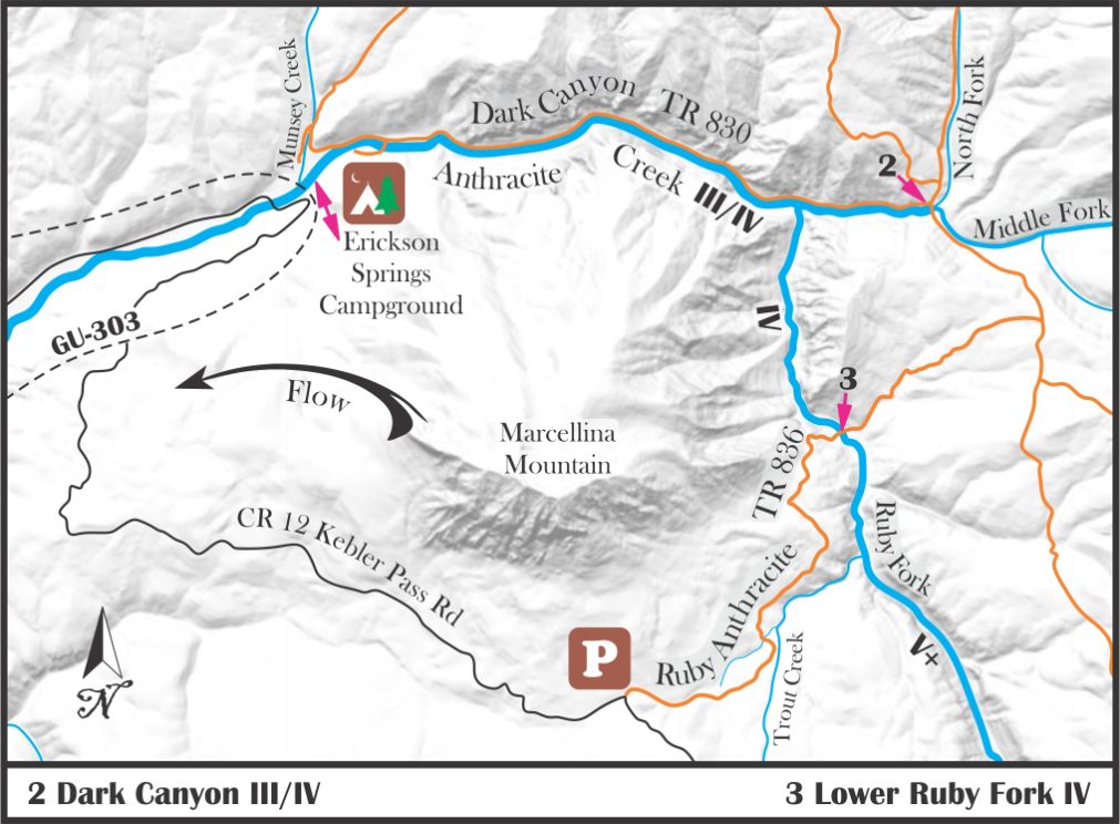
Trail 830 heads out of Erickson Springs Campground and takes you up Dark Canyon along Anthracite Creek. The trail crosses the river by bridge just after you begin and heads up stream allowing you to scout the run but also choose how far up you would like to go. It’s 3.9 miles to the confluence of the North and Middle Forks so one could make a day of it hiking in and running back to their car or you can hike in as far as you feel to extend the Lower Annie Run. Depending on how far up you hike, the run is pretty consistent techy class III/IV with lots of rocks and trees. You will likely have to portage around a few fallen trees. Ice Trekkers may be needed for the hike in.
Lower Ruby
On the south side of Marcellina Mountain lies a trailhead that heads into the Ruby Fork Basin, just below the Class V+ mank, allowing you to run a nice stretch of continues class III/IV with a few solid class IV drops as it runs into the confluence with the main creek in Dark Canyon. Be on the lookout for fallen trees and expect to portage a few times because of them. The typical run is to go from here to Erickson Springs though one could continue down the Lower Annie as well. Ice Trekkers may be needed for the hike in.
Ruby Fork of Anthracite Creek
Class: V+ mank, two mandatory portages
Who: Those seeking type II fun that boarders on type III
Length: 11 miles
Season: Spring Runoff
Gauge: visual
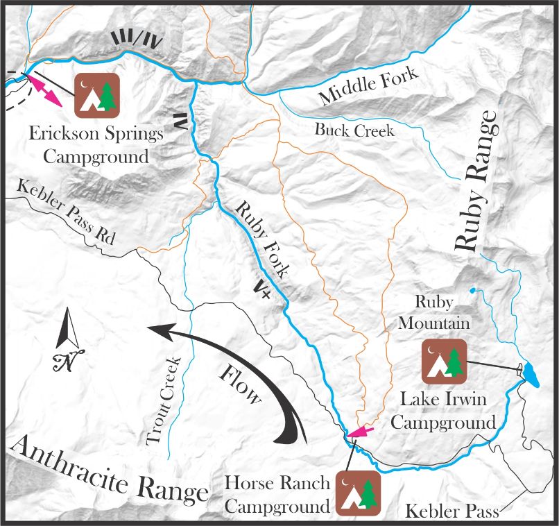
If you read class V+ mank above and your nipples got hard, this may be the run you’re looking for. It was described in “Whitewater of the Sothern Rockies” as not worth running again until it has been seriously flossed but beauty is in the eye of the beholder. All descriptions speak of micro to nonexistent eddies, mandatory portages, trees, land slide banks, rocks, rocks and rocks but some look for that type of fun, in climbing we call them “Choss Pilots”.
To put in, head up to Horse Ranch dispersed campground and head about 1/3 of a mile downstream past the first cascade. Take out at Erickson Springs Campground.
Water sports are inherently dangerous sports in which severe injuries or death may occur.
Do not use this website or maps unless you are an expert, have sought out and obtained qualified professional instruction or guidance, are knowledgeable about the risks involved, and are willing to assume personal responsibility for the risks associated with these activities. If you have any doubts in your ability please stay off the water.
DO NOT USE THIS WEBSITE OR MAPS UNLESS YOU ARE WILLING TO ASSUME PERSONAL RESPONSIBILITY FOR THE RISKS ASSOCIATED WITH THE ACTIVITIES DESCRIBED OR DEPICTED!!!


